
Perth Amboy Neighbor Sources
The public block record is a chain of different sources. Middlesex GIS shows parcel shapes, tax-block context, feature identifiers, and an OwnersName display field. The assessor maintains parcel information such as ownership, mailing address, situs, and assessment context. Deeds identify recorded parties, while municipal boards can supply public project addresses or applicants. Each source has a different scope, so a parcel owner must never be labeled a personal neighbor or a present occupant.
| Source | What It Shows About a Block | Access |
|---|---|---|
| Middlesex GIS parcel layer | Parcel geometry, OwnersName display, tax-block and feature context | Public MapServer query and map metadata |
| Perth Amboy Tax Assessor | Maintained parcel ownership, mailing, situs, and assessment context | Local office and city tax-map route |
| Middlesex official records | Recorded parties, instruments, dates, and legal-description links | County index and custodian channels |
| Municipal boards | Public project addresses, applicants, actions, and meeting materials | City board and department routes |
| Community programs | Ways to contact a program or neighborhood officer | Official city information, not a membership roster |
A mailing address can differ from a parcel’s situs address, and a recorded party can differ from both. GIS supplies spatial relationships. It does not prove that a person lives beside the subject parcel. A historic directory or newspaper can date a past connection, but it cannot fill a current block roster.
Start Perth Amboy Neighbors in GIS
The Middlesex Parcels_Public layer is the local spatial starting point. Its documented fields include an object identifier, OwnersName display field, geometry, and query controls. Locate the subject parcel through a mapped address, feature identifier, block, or lot. Return the geometry and note the parcel identifier before examining the parcels around it.
The service supports query and output choices including JSON, GeoJSON, and PBF. It has a maximum record count of 2,000. Constrain the query to a parcel or block. A very broad pull is less reliable for a block question and risks obscuring the actual adjacent features. The layer is updated with assessor information, so it should be treated as a dated snapshot.
The parcel-layer display and query page shows the fields relevant to a Perth Amboy neighbors search.
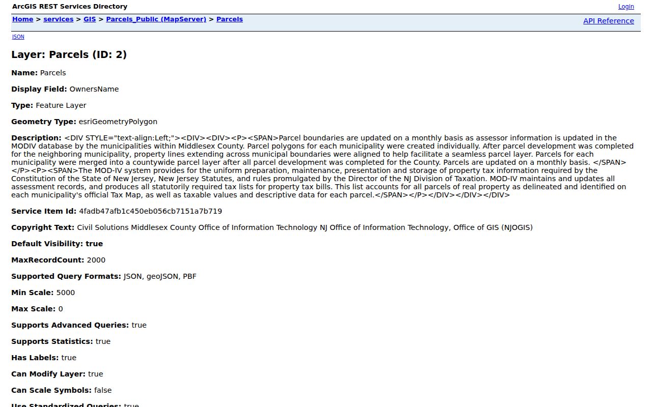
The field list supports parcel comparison. It does not furnish an identity directory for a block.
Trace Perth Amboy Neighbor Parcels
Use the mapped subject parcel to identify polygons that share a boundary or sit directly across a street. The public metadata does not document a one-click neighbor button, radius tool, or standardized adjacency report. This is an individual parcel process. A public right-of-way can separate two polygons, and a tax block is not always the same as a block in ordinary speech.
- Query the subject parcel by feature ID, block and lot, or mapped address, then save its geometry and identifier.
- Inspect the map for touching polygons and direct across-street parcels. Record each parcel’s block, lot, street frontage, and feature context.
- Query each adjacent parcel separately. Do not download an expansive layer result simply to make a block list.
- Compare an OwnersName display with assessor context and, when needed, a county instrument by lot, block, legal description, or map number.
- Save the access date and stop at the parcel relationship. Do not recast a displayed owner as a neighbor or occupant.
Corner parcels may have two street fronts. A blank or redacted name can reflect Daniel’s Law or a field limitation. For a full named-street chain, the Perth Amboy street directory follows the address sequence without claiming everyone on the street is a current resident.
Deed records add a time layer after the parcel map. Middlesex Official Records can be searched by lot and block, parcel ID, map number, legal description, party name, instrument, or date. Its online coverage begins with deeds in 1929, mortgages in 1950, and other document types in 1958. Those records identify parties to a recorded instrument, not people currently present on the land. For older instruments, the County Clerk record room and the New Jersey Archives are the documented fallback channels.
Perth Amboy Neighbor Contact Routes
There is no verified public neighborhood-association roster in the researched city or county sources. The appropriate official contact layer is the city’s municipal-board index and its community-program pages. Board agendas or minutes may show a project address, applicant, or official action. They are not household directories. Neighborhood Watch is a contact mechanism that connects residents and officers, not a public list of members.
Historic Preservation
Use the city boards route for public preservation matters and address-linked meeting material when available.
Planning and Redevelopment
Planning and redevelopment materials can place a public project at an address and identify official actions.
Citizen Public Safety Board
Use the city’s civic index for public-board context, not for a neighborhood membership claim.
Neighborhood Watch
Community programs offer contacts and meetings with neighborhood officers rather than a roster of participants.
The Perth Amboy boards index identifies the civic bodies available for address-based public context.
Historic Preservation, Planning, Redevelopment, Library Board, Arts Council, Business Improvement Corporation, Green Team, and Citizen Public Safety Board are listed there. The listing does not establish a neighborhood association directory.
Perth Amboy Neighbor Project Addresses
Planning, zoning, preservation, and permit material can add civic context around a parcel. A final permit, board action, or public hearing may date a project or identify an applicant. It does not establish that the applicant, contractor, owner, or agent lives on that block. Ask the appropriate City Clerk, Planning, or Zoning custodian for final public portions and the exact address and date range.
The city’s business-registration permit page documents an application route, but no public searchable permit roster was found. Treat a permit form as a record-access clue, not a neighbors list.
When a project record is relevant, connect its address to block and lot before comparing it with a deed or parcel record.
Perth Amboy Neighbor Community Programs
Neighborhood Watch groups meet with neighborhood officers under the city’s community-program information. The same source also lists CERT, a Youth Police Academy, and a Domestic Violence Response Team. These are ways to learn about public-safety programs or request the right contact. They do not publish a member roster and should not be used to infer who lives nearby.
For a report or exact incident-record request, the Police Records and Services route lists record-specific procedures. Requests may require a report number, date, location, and requester relationship. A name in a report is not proof of a continuing connection to a block.
The community-program page is the source for the Perth Amboy neighbors contact context.
The program page should be used to find an official contact channel, not to compile names from the surrounding area.
The Police Records and Services page supplies the separate records-access route.
Its presence distinguishes a record request from a neighborhood membership search.
Compare Perth Amboy Neighbor Sources
Official sources disclose their record type, custodian, and update context. A commercial neighbor-search category may combine old directories, assessment extracts, court indexes, and other material into a profile, but its matching rules and refresh dates are not an authoritative parcel relationship. Start with the official map and custodian. Use a source’s date and field label to describe what it actually shows.
| Official parcel and civic records | Commercial neighbor-search category |
|---|---|
| Shows a defined custodian, record role, parcel field, or public board action. | May merge material with unclear source timing or matching rules. |
| Can be checked against geometry, block and lot, document date, or board record. | Can confuse owner, past occupant, relative, and adjacent-party roles. |
| Has a correction or request route through the named custodian. | Does not replace the local office’s correction process. |
A careful Perth Amboy neighbors result says “adjacent parcel,” “recorded party,” or “public project address,” rather than attaching a personal label the record cannot support.
Privacy Limits for Perth Amboy Neighbors
Public parcel, deed, and GIS layers do not list every person at an address. Household members, visitors, utility customers, delivery recipients, and protected people may not appear. New Jersey voter tools are not an everyone-on-this-block screen, and voter-file use is restricted. Motor-vehicle address data is protected under DPPA. A historical directory or newspaper notice can date a location, but it cannot prove current presence.
Daniel’s Law protects covered people’s home address and unpublished phone information from government web disclosure. The Address Confidentiality Program supplies a substitute address and mail forwarding for qualifying participants. The Office of Information Privacy reported protecting more than 10,000 covered persons in April 2025, which explains why GIS or government sites can show a blank or redacted field. A missing field is not permission to search around the protection.
New Jersey's voter system is also not a block-level resident list. Its official function is registration status and election information, and the state form inspected during research was not accessible for a verified public field display. The voter statute limits solicitation uses. Motor-vehicle address information has separate DPPA protections. Where a parcel, record, or board item needs correction, contact the named custodian with the source date and block or lot instead of trying to reconstruct protected details from unrelated records.
Lawful use. Perth Amboy neighbors records are for lawful parcel and civic research. Do not use a mapped address, a board record, or any name field to watch, contact, harass, intimidate, or harm another person.